
By Sheri Rosenbaum
As summer ended and fall was upon us, it was time to dust off the cross bike and hit the trail. Last fall my riding companion and I looked for a new adventure within a day’s drive of Chicago and decided on the Katy Trail in Missouri. The Katy is the longest developed rails-to-trails path in the country, and the surrounding area is rich in history and natural beauty. What follows is a recap of our ride, along with numerous tips and suggestions should you decide to ride the Katy yourself.
Trail History
The trail is built on the former corridor of the Missouri-Kansas-Texas Railroad (MKT, or Katy), is 240 miles long and runs between Clinton, Missouri (in the west, central part of the state) and Machens, near St. Louis, with 26 trailheads and four fully restored railroad depots. Much of the trail runs along the Missouri River on one side and high bluffs on the other, which offers spectacular views. Many of the trailheads have bathrooms and water available, some providing a pump and bike tools.
You’ll continually be reminded of the trail’s history as you see old telegraph poles and other remnants of the railroad’s past. The trail passes over numerous pony-truss, through-truss and trestle bridges on its route. Along the trail you’ll ride through small rural towns that once thrived along the railroad corridor. These communities make great places to stop and explore. (Note: Many places are closed on Sunday and/or Monday, so plan ahead for food).
Lewis and Clark are also part of the trail’s history. Napoleon offered the Louisiana Territory for sale in 1803 and President Thomas Jefferson directed Lewis and Clark to map and explore the lands west of St. Louis to find a water route to the Pacific.
Daniel Boone is also an iconic figure who plays into the history along the trail. Having endured legal and financial setbacks, Boone sought to make a fresh start by leaving the United States. In 1799, he moved his extended family to what is now St. Charles County, Missouri, which was then part of the Spanish Louisiana.
Which Type of Bike to Ride
The trail is crushed limestone and very well maintained. There were only a handful of sections that were “rough,” and those were clearly marked with signage. I’d recommend a cross or hybrid bike, but certainly a road (minimum 25mm tires), MTB, or a fat tire bike would work, too. Since this is an old railroad bed, the grades are minimal. Most of the sections we rode had 300 feet of climbing over 50 miles. The west end of the trail had more climbing, with about 1,000 feet over 50 miles.
There are a few bike shops along the trail that rent eBikes, so if a friend or spouse is not as strong a rider as you, they can still keep up and enjoy the trail.
Self-Supported or Day Rides
The majority of the riders we came across were riding the full trail and doing a self-supported “through” ride, carrying their belongings with them and riding the entire trail from one end to the other. The ideal way to do this is park in St. Charles and take the Amtrak train or hire a shuttle west to Sedalia. Then ride east back to St. Charles. You can either camp or select from a variety of inns, B&Bs or hotels along the trail.
We decided to use shuttles to ferry us to some starting locations, or simply ride out and back each day, staying in hotels. If we were to do it again, I think we’d go the self-supported end-to-end route and stay at hotels or inns along the way. Many of the bike shops rent panniers, so you don’t need to incur the added expense of purchasing them if you don’t already own them.
Something For Everyone
The trail offers you options for cycling, equestrian riding, and hiking. So if you are traveling with a non-cyclists, there are options for them as well along the trail that don’t include a bike. Non-cyclists can also shop at many of the antique stores and check out any of several local wineries along the way. Then meet up with you for lunch at one of the small towns along the trail.
Our Itinerary
We decided to ride the trail mostly west-to-east for two reasons. First, we’d end up two hours closer to Chicago on the last day, thus less of a drive home. Second, prevailing winds and down river is west-to-east. But Mother Nature threw us a curve ball two of the days we rode, with uncommon easterly winds.
Sunday, October 9th
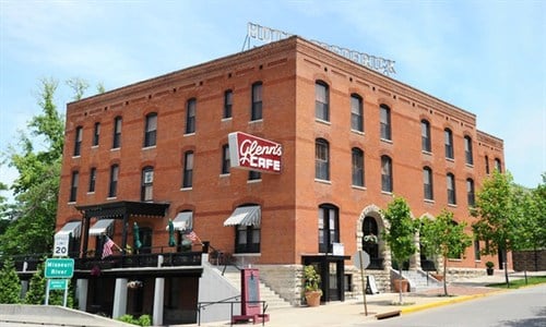
Departed Chicago and headed for Boonville, Missouri (mile marker 191.8). We arrived about 4:30 p.m. and checked into the Hotel Frederick. Built in 1905, the Hotel Frederick is a significant local and state historical landmark, and is the best example of Romanesque Revival architecture in the region. The Frederick caters to cyclists – even offering bike storage in their basement – and is located directly across the street from the Katy Trail.
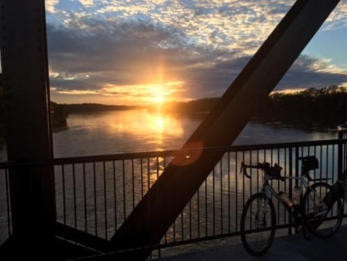
We decided to take a short sunset ride to stretch our legs, taking the bridge across the Missouri River and heading out about seven miles east. Then on the way back we stopped on the now-closed Katy Bridge to watch the sunset over the river. The bridge was built in 1931-32 to replace an 1873 MKT structure. It has four trusses over the water and a vertical lift in the middle. It’s very impressive to see up close. Sunset from the bridge was breathtaking and truly set the mood for the remainder of the trip.
Since it was late, we ate a yummy dinner at The Fred in the hotel and were in bed by 9:30 to get an early start the next day.
Monday, October 10th
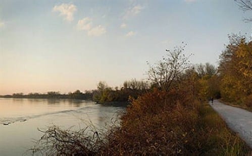
We hired a shuttle service, Cotten’s Bikes & Shuttle, to take us to N. Jefferson (mile marker 143) which is just a few miles from the state capital (Jefferson City). The cost was $45/person, which was well worth it. If you have time, you can ride the Jefferson spur into the city and tour an abandoned prison and other sites. We decided to skip the extra miles since we already had 50 miles back to Boonville. This section of the trail was quite scenic, with lots of wildlife, including turkey vultures, bald eagles, blue jays, white tail deer, and the crazy kamikaze red squirrels that would dart out across the trail.
Much of this section of the trail paralleled the river, so we enjoyed great views to the left and bluffs to our right. Not realizing that most places are closed on Monday, we did not get to eat lunch until 3 p.m., when we arrived back in Boonville. We stopped at the Main Street Diner and enjoyed a wonderful home cooking-style meal and friendly locals interested in our trip. (As I noted earlier, on Sundays and Mondays you’re well-served to carry some hearty provisions for situations like this one, so you don’t bonk out on the trail.)
We stayed at the Hotel Frederick a second night and walked a few blocks to Maggie’s Bar and Grill for dinner. I can recommend Maggie’s, too.
Tuesday, October 11th
We hired the same shuttle service again this morning at the same cost as Monday to take us 50 miles west to Green Ridge (mile marker 239). The scenery was a bit different today as we were now away from the river. It was mostly farms and forest and there was more climbing, with about 1,000 feet over the 50 miles – but all gentle grades between 1-3%.
We stopped along the trail in Pilot Grove at Katarina’s Cafe. Again, home-style cooking with great burgers and salads. If you are so inclined, there’s also homemade pie. Just remember: you have to get back on the bike, so don’t eat yourself into discomfort!
Once in Boonville, we packed the car and drove east to Hermann. This town is two miles off the trail, but it’s a cute little German town known throughout the state. If you are there in October over a weekend, there are numerous Octoberfest activities. Hermann also has a number of wineries. We stayed at the Hermann Crowne Hotel and were not thrilled. There are many other locations to pick from, so I would suggest you check them out if staying there.
Wednesday, October 12th
In the morning the forecast was for rain, so we walked down the road to Lyndee’s for an amazing breakfast. I highly recommend the pancakes they make from scratch – and I’m not a pancake fan.
After breakfast, the skies were clearing so we drove via Route 94, a scenic two-lane hilly, windy country road to Treloar (mile marker 84.7). The road passed through vineyards and farm fields and was quite pretty. We did not shuttle today and chose to do an out-and-back ride instead.
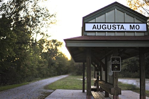
Just as we got to Augusta (mile marker 66.3) it started to rain. So we hunkered down at the trailhead with some other cyclists and waited for the storm to pass. Because of the strong headwinds back to Treloar, and another storm pending in the afternoon, we decided to head back. We stopped at a cute bar in Marthasville (mile marker 77.7) called Two Gables for lunch and continued on back to Treloar. Being persnickety about getting our daily mileage in, and with the storm still holding off, we rode past Treloar for a few miles to get 50 total for the day.
From Treloar we drove Route 94 to St. Charles (mile marker 39.5). We stayed at the Country Inn and Suites, which was in historic St. Charles, as well as right on the Katy Trail.
Thursday, October 13th
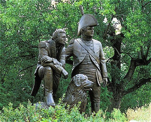
Today was our last day, and we decided to do another out-and-back before driving home. No need for a shuttle here. We rolled out of bed, had breakfast, and were 30 yards from the trail to start. Riding east, our destination was the town of Defiance (mile marker 59.1). This portion was back along the river, with bluffs on one side. The 40-mile round trip ended at the St. Charles railroad depot for some pictures with a massive statue of Lewis and Clark, and their dog, Seaman, a big Newfoundland.
With a late checkout arranged, we were able to shower and hit the road by 1 p.m. The trip was really special, and I can highly recommend it for any level cyclist. Being mid-October, we were hoping for some amazing fall foliage, but we were probably a week too early. The leaves were just starting to change. The trail was not very crowded but I’m sure weekends during the summer it could be packed. I highly recommend making hotel and shuttle reservations beforehand. Hotels, especially, get booked fast, and you don’t want to be without a place to stay.
One last word of caution: cell phone and Internet service is very spotty along the trail. After the first day, we took a paper map with us (available at any hotel, trailhead or bike shop) so we knew how far the next town was and what services were offered. The trailheads did have town history, mileage and a few points of interest.
Post Script
On Saturday, December 10, 2016, a 47.5-mile trail was opened to connect the Kansas City area with the Katy Trail, providing almost 300 miles of uninterrupted path stretching all the way across the state from K.C. to the St. Louis area.
Sheri Rosenbaum is a cycling friend and triathlete who is active as a writer for her own blog Fifty, Fit and fabulous and a variety of other sites including RoadBikeRider and BTF from time to time.
Looking for more information on the Katy Trail, check out Bike Katy Trail, considered the best source available for cycling on the Katy Trail. it includes everything from hotels and a trip planner to Katy Trail T-shirts! You can also visit the official Missouri State Parks Katy Trail State Park site.

![[Alt-Text]](https://sp-ao.shortpixel.ai/client/q_lqip,ret_wait,w_400,h_533/https://biketourfinder.com/wp-content/uploads/2018/06/KatyTrailBridge1RosenbaumWEB.jpg)


